


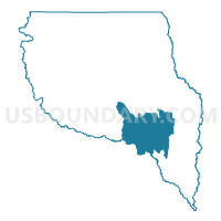
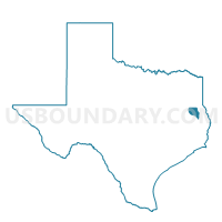
Voting District 0044, Nacogdoches County, Texas
About
Outline

Summary
| Unique Area Identifier | 676050 |
| Name | Voting District 0044 |
| County | Nacogdoches County |
| State | Texas |
| Area (square miles) | 84.08 |
| Land Area (square miles) | 79.58 |
| Water Area (square miles) | 4.49 |
| % of Land Area | 94.66 |
| % of Water Area | 5.34 |
| Latitude of the Internal Point | 31.48234090 |
| Longtitude of the Internal Point | -94.50068700 |
Maps

Graphs
Select a template below for downloading or customizing gragh for Voting District 0044, Nacogdoches County, Texas


Neighbors
Neighoring Voting District (by Name) Neighboring Voting District on the Map
- Voting District 0003, Angelina County, TX
- Voting District 0019, Angelina County, TX
- Voting District 0042, Nacogdoches County, TX
- Voting District 0043, Nacogdoches County, TX
- Voting District 0046, Nacogdoches County, TX
- Voting District 0047, Nacogdoches County, TX
- Voting District 0048, Nacogdoches County, TX
Top 10 Neighboring County Subdivision (by Population) Neighboring County Subdivision on the Map
- Nacogdoches CCD, Nacogdoches County, TX (51,905)
- Huntington CCD, Angelina County, TX (11,260)
- Chireno-Martinsville CCD, Nacogdoches County, TX (5,120)
Top 10 Neighboring Unified School District (by Population) Neighboring Unified School District on the Map
- Nacogdoches Independent School District, TX (46,647)
- Lufkin Independent School District, TX (46,464)
- Huntington Independent School District, TX (8,301)
- Woden Independent School District, TX (3,064)
- Chireno Independent School District, TX (1,642)
- Etoile Independent School District, TX (1,453)
Top 10 Neighboring State Legislative District Lower Chamber (by Population) Neighboring State Legislative District Lower Chamber on the Map
Top 10 Neighboring State Legislative District Upper Chamber (by Population) Neighboring State Legislative District Upper Chamber on the Map
Top 10 Neighboring 111th Congressional District (by Population) Neighboring 111th Congressional District on the Map
Top 10 Neighboring Census Tract (by Population) Neighboring Census Tract on the Map
- Census Tract 9503.02, Nacogdoches County, TX (7,509)
- Census Tract 9503.01, Nacogdoches County, TX (7,258)
- Census Tract 11, Angelina County, TX (6,079)
- Census Tract 9511, Nacogdoches County, TX (5,120)
Top 10 Neighboring 5-Digit ZIP Code Tabulation Area (by Population) Neighboring 5-Digit ZIP Code Tabulation Area on the Map
- 75901, TX (29,036)
- 75961, TX (14,910)
- 75949, TX (7,976)
- 75944, TX (1,301)
- 75937, TX (994)
- 75978, TX (144)